Big Frog Wilderness Hiking
"A wilderness...is hereby recognized as an area where the earth and its community of life are untrammeled by man, where man himself is a visitor who does not remain."
- Wilderness Act of 1964
"A wilderness...is hereby recognized as an area where the earth and its community of life are untrammeled by man, where man himself is a visitor who does not remain."
- Wilderness Act of 1964


![]()

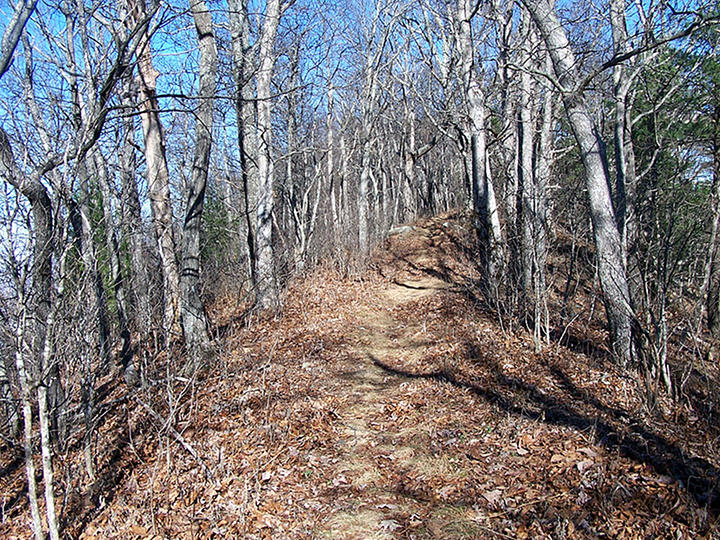
The 8,082 acre Big Frog Wilderness has 33 miles of hiking and backpacking trails. There are 9 trails that traverse Big Frog Mountain. Most begin in the Cherokee National Forest ending in the Big Frog Wilderness. The Big Frog Wilderness in Tennessee is the continuation of the Cohutta Wilderness in Georgia and together they encompass 45,112 acres and 127 hiking miles spanning two states representing the largest contiguous Federally Designated Wilderness east of the Mississippi.
Even though they are contiguous they also couldn't be more different. Big Frog Wilderness is Big Frog Mountain. All the trails either climb the north side of the mountain or traverse it. Big Frog Mountain is over 4,200 feet and is the highest peak in the area. Hemp Top Trail from the Cohutta Wilderness connects the Cohutta Wilderness to Big Frog Mountain and depending on which trailhead it may be accessed from Blue Ridge, GA or Chestnut Mountain above Beech Bottom Trail just across the Georgia border in Tennessee. The shortest way up Big Frog Mountain is via Hemp Top Trail: TN Section in the Cohutta Wilderness and is a gorgeous hike, especially in the winter.
Once you enter the Big Frog Wilderness imagine the trail structure as a horseshoe about to be thrown with the left part being Wolf Ridge Trail (most western trail), in the center is Big Frog Trail, and the right part of the horseshoe being Licklog Ridge Trail (most eastern trail). These 3 trails bring you up on separate spurs of Big Frog Mountain and offer great views of the surrounding area below. The other 6 trails are connecting trails which either traverse the mid to upper slope or the valley of Big Frog Mountain.
Big Frog Trail defines the Big Frog Wilderness. This 5.5-mile cornerstone trail is well designed and bisects the Big Frog Wilderness with 5 other trails that junction with it. The trail takes you to the summit of Big Frog Mountain at 4,224 feet on narrow ridges with great views to the West and East and on the way traverses a tunnel of trees that remind you of an enchanted forest. The best trail in the wilderness.

Big Creek Trail is surprisingly the only trail that resembles the Cohutta Wilderness. It follows the decent size Big Creek in the valley surrounded by eastern Hemlocks before climbing a beautiful ridge trail connecting with the Big Frog Trail at the geographic point called Chimney Top. A great place to take a lunch break.
Wolf Ridge Trail is a blast. This short 2.7-mile ridge trail climbs and intersects with Hemp Top Trail on Chestnut Mountain in the Cohutta Wilderness. The trail offers fantastic views of the Tennessee Valley and intersects with Grassy Gap Trail at a beautiful trail junction marked by an idyllic Oak tree at mile 2. Another good place to take a break.
Licklog Ridge Trail is the longest trail at 5.9 miles and the most physically demanding. It offers views of the Ocoee river and the mountains of North Carolina. At mile 5 the trail offers an incredible view of the summit of Big Frog Mountain and the valley below containing the east fork of Rough Creek which can be heard after sustained rainfall.
The 5.0-mile Grassy Gap Trail is one of a kind in the area. It literally traverses the midslope of Big Frog Mountain on a skinny footpath traversing over cool rock formations in the crevices of the mountain with some filled with water. It is fairly level but still challenging due to the narrowness of the trail.
Fork Ridge Trail is part of the Benton Mackaye Trail(BMT) system and is a beautiful connector trail especially in the Fall. Yellow Stand Trail is a great alternative to return to your vehicle depending on the trail loop. Rough Creek Trail connects Big Frog Trail to Licklog Ridge Trail in the valley of Big Frog Mountain. West Fork Trail continues section 11 of the BMT and from its trailhead, the Ocoee River is less than 3 miles on the BMT.


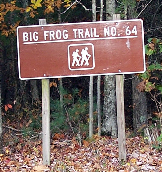
Trailheads are generally well marked and parking areas are provided. The exception is the Licklog Ridge Trail. The trailhead is 100 meters up in the woods and is easy to miss.
There are two entrance points to the Big Frog Wilderness from major highways. The first is to enter from Hwy 411 in Cisco, GA and drive like you are entering the Cohutta Wilderness. The northwest trailhead for the Jacks River Trail is just across the Georgia border in Tennessee on Forest Service Road 221. Continue on FS221 to Big Frog Wilderness. Fortunately, the forest service roads in Tennessee are much better than any in the Cohutta Wilderness.
The second entrance via a major highway is by entering from Hwy 64 in Tennessee. Take the Hwy 64 exit from Hwy 411 and drive 18 miles east before arriving at the #3 Ocoee Power Station. Take a right crossing over the Ocoee river and passing the #3 power station on your right before entering the Cherokee National Forest on Forest Service Road 45.
It is approximately 2.7 miles to the T-intersection with FS 221. From there it is a short distance to the trailheads for Big Frog, West Fork, and Licklog Ridge. Click to the trail for specific driving instructions or go to the 3D map at this Caltopo link https://caltopo.com/m/B300
| Big Frog Wilderness | ||
|---|---|---|
| Wolf Ridge Trail: | 2.7 miles | |
| Grassy Gap Trail: | 5.0 m | |
| Big Creek Trail: | 4.2 m | |
| Yellow Stand Lead Trail: | 2.3 m | |
| Big Frog Trail: | 5.5 m | |
| Rough Creek Trail: | 3.0 m | |
| Fork Ridge Trail: | 2.0 m | |
| West Fork Trail: | 2.4 m | |
| Licklog Ridge Trail: | 5.9 m |
Hikers and backpackers should leave a detailed trip plan with someone expecting their return since cell service is unpredictable in this mountainous area.
cohuttawildernesshiking@yahoo.com